Tropical Storm Francine strengthens to Cat 1 hurricane & heads toward Louisiana, South MS
READ MORE
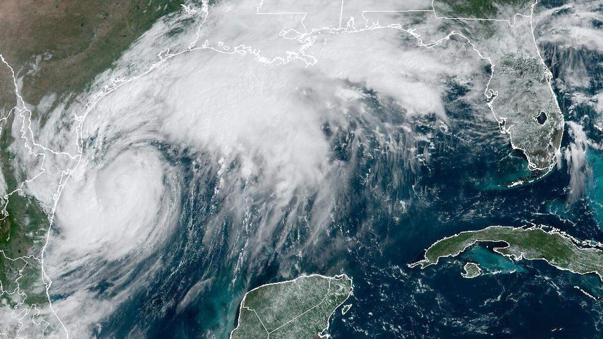
Hurricane Francine
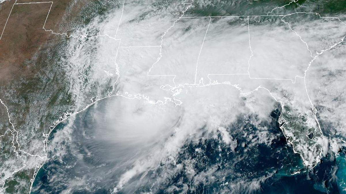
Francine is expected to make landfall Wednesday as a Category 1 hurricane. While the storm appears headed to the Louisiana coast, Southern and coastal Mississippi could see a risk of flash flooding, according to the National Weather Service.
Expand All
▪ NOTE: This story has been made available for free, for all readers. Please consider supporting local journalism through the purchase of a digital subscription.
Editor’s note: This report is from Tuesday, Sept. 10. Wednesday’s live reports as Francine approaches landfall can be found here.
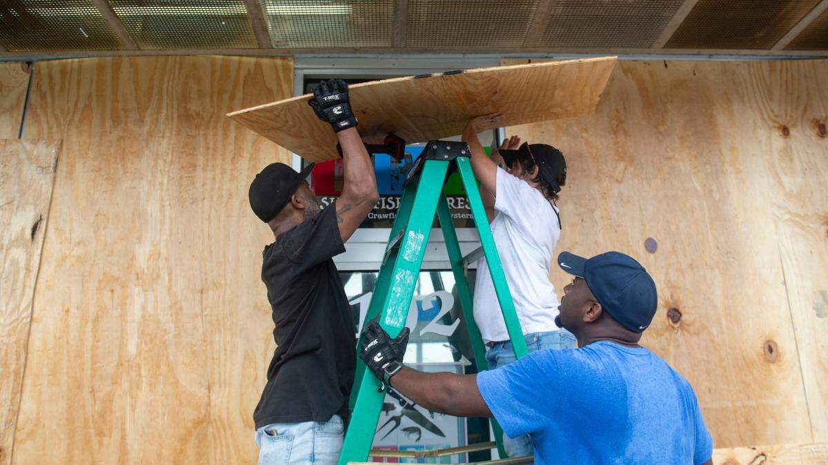
South Mississippi prepares Tuesday for Hurricane Francine, which is expected to become a hurricane before making landfall in Louisiana Wednesday.
Counties and cities across the Coast are declaring a state of emergency as the storm approaches.
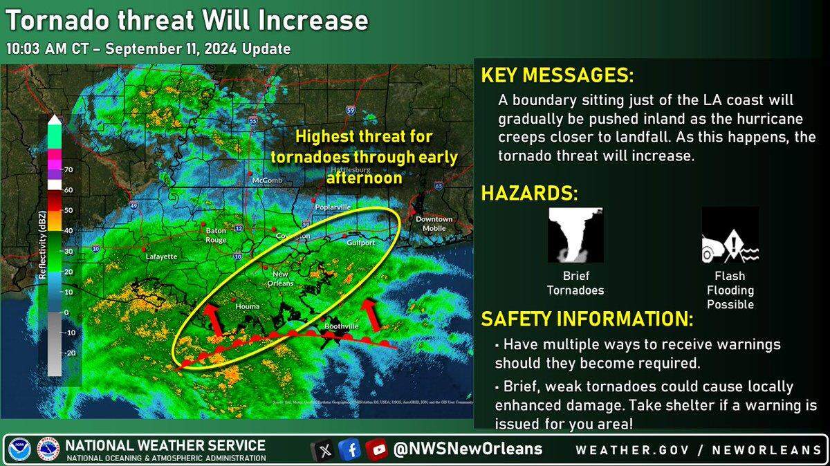
“Francine is expected to bring multiple hazards to the area, including heavy rainfall, coastal flooding, gusty winds and a threat of tornadoes beginning late tonight and continuing into Thursday morning,” the National Weather Forecast Office in New Orleans reported Tuesday morning.

10 p.m. Francine strengthening overnight
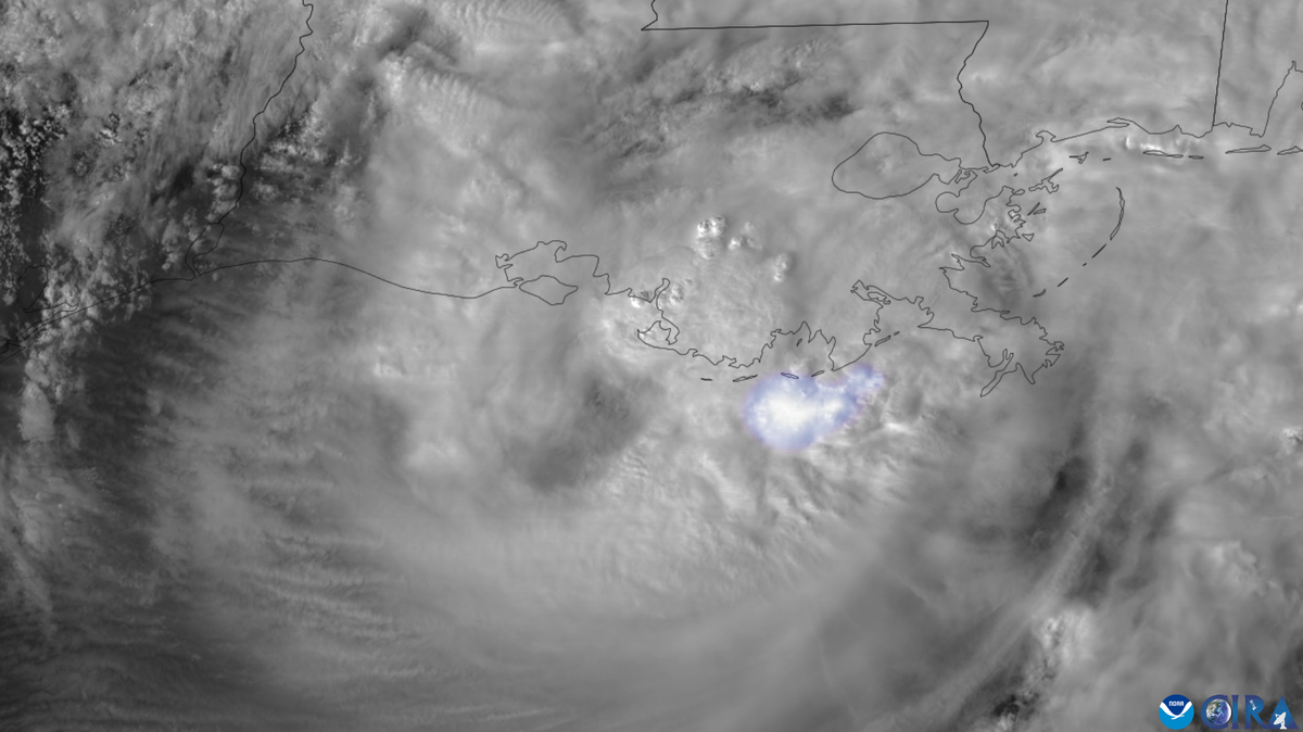
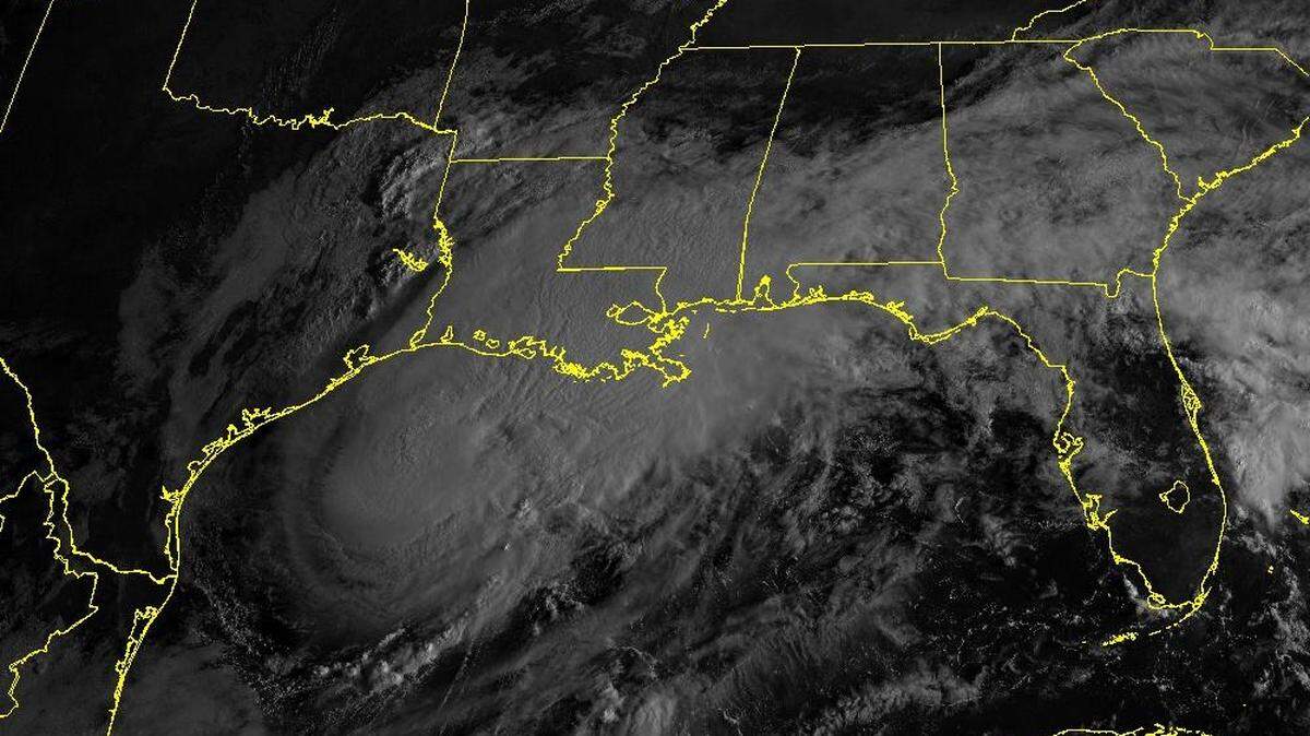
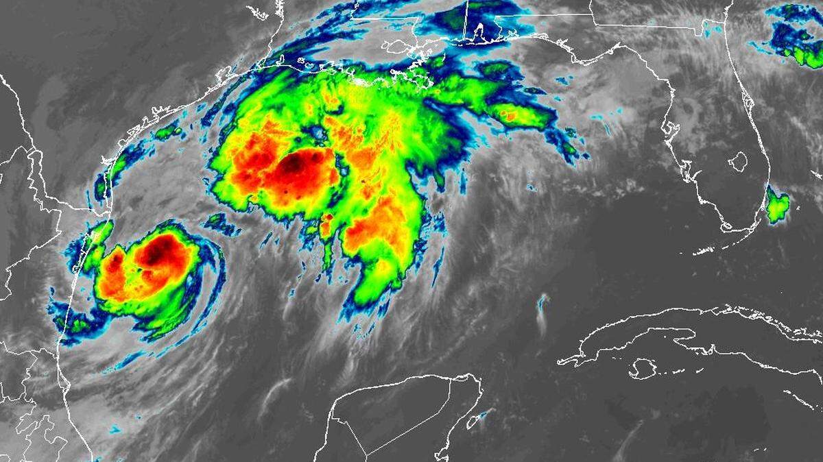
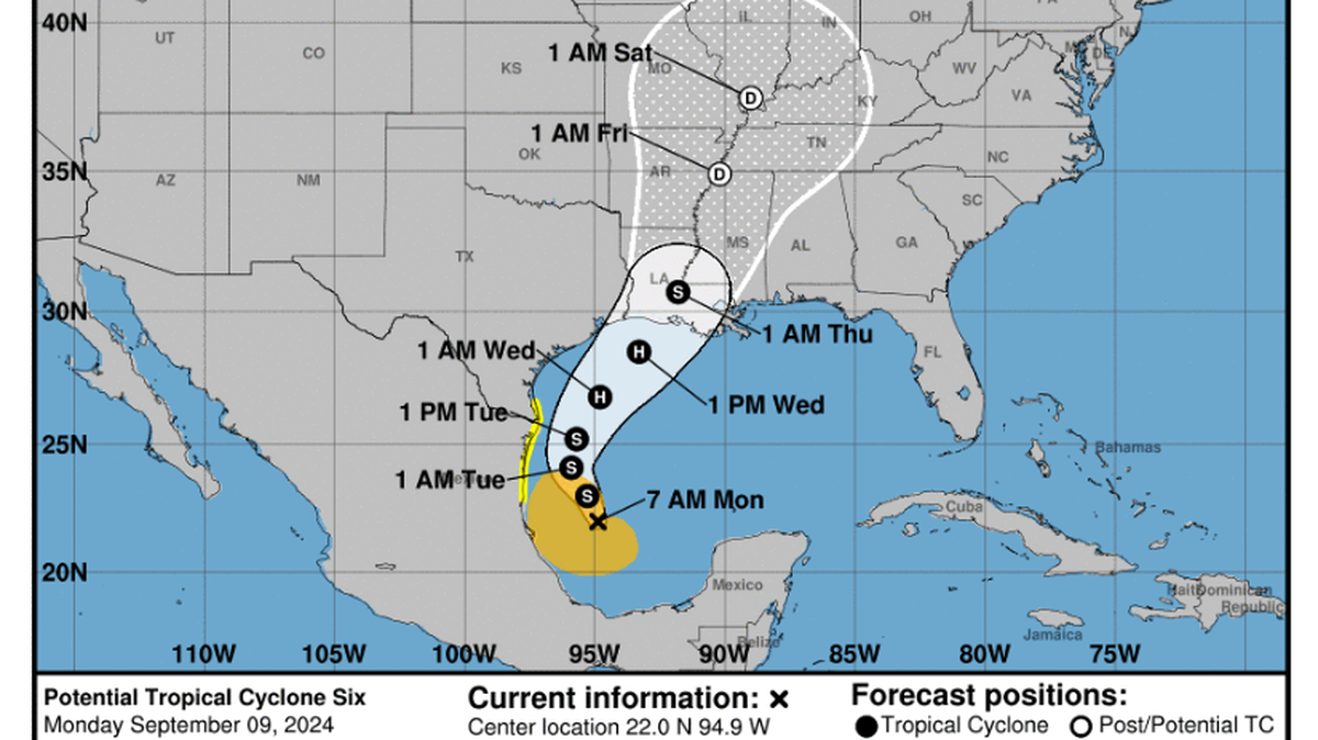
Hurricane Francine was gaining strength Tuesday night over warm Gulf waters with low wind shear, maintaining Category 1 strength of 75 mph, the 10 p.m. update from the National Hurricane Center said.
Whether Francine reaches Category 2 status is doubtful as it continues a northeasterly track toward the Louisiana shoreline, where the storm is expected to make landfall Wednesday afternoon or evening. The 10 p.m. update had winds at 90 mph at landfall, a Category 1.
“A notable increase in shear and intrusions of dry air should end the opportunity for strengthening just before Francine reaches the coast,” the hurricane center update said. “Rapid weakening is expected after the cyclone moves inland.”
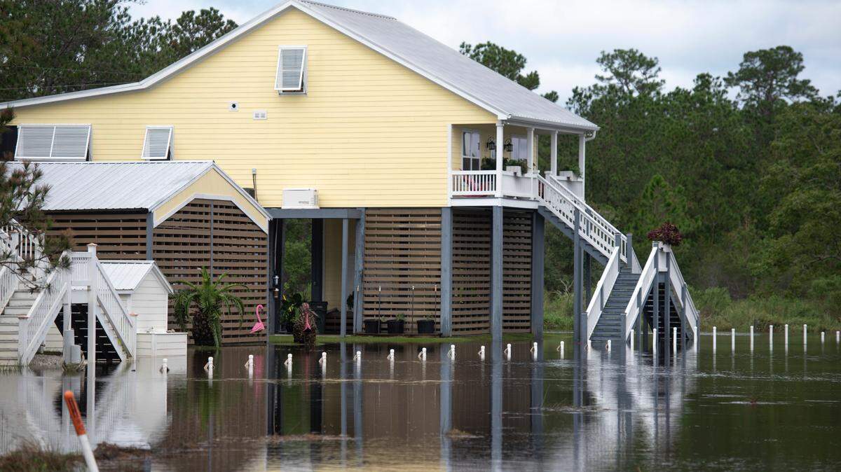
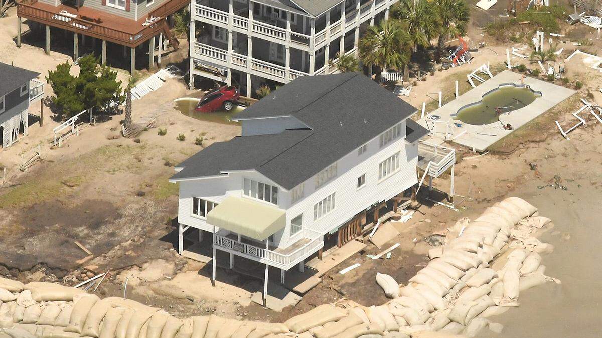
Even so, Francine is forecast to pack life-threatening storm surge, hurricane-force winds along the Louisiana Coast and tropical-storm-force winds along Mississippi’s coastline, flash-flooding and, possibly, tornadoes.
Residents should monitor the storm closely. Hurricane shelters will open Wednesday morning across South Mississippi, with locations listed below.
7:20 p.m.: Landfall as a Cat 1?
Dry air and wind shear are expected to slow intensification of Hurricane Francine as it tracks southeast toward Louisiana’s shore, leading the National Hurricane Center to forecast landfall as a Category 1 hurricane as opposed to Category 2.
6:45 p.m.: It’s a hurricane
In the National Hurricane’s 7 p.m. report, which was delivered early, Tropical Storm Francine was upgraded to a hurricane. The storm now has maximum sustained winds of 75 mph. No additional watches or warnings were delivered in the report.
5:55 p.m.: Harrison County sand beaches closing
The Harrison County Board of Supervisors has announced the closure of all county sand beaches, effective 12:00 a.m. on Wednesday, Sept. 11.
5:30 p.m.: Jackson County opening shelter
The Jackson County Office of Emergency Services has called for the American Red Cross to open a 361 Emergency Shelter at 9 a.m., Wednesday. The shelter’s address is 5500 Ballpark Road, Vancleave.
Officials suggest bringing the following: pillow and bedding, clothing, medications, snacks, games, stuffed animal, blanket for children, emergency kit and electronic device charger(s).
Officials warn against bringing the following: alcoholic beverages, illegal drugs and weapons.
5:20 p.m.: Voluntary evacuation in Hancock County
The Hancock County Emergency Management Agency has issued a voluntary evacuation of low-lying areas beginning at 7 p.m. Tuesday. Residents might want to evacuate if they live on rivers, river inlets, bayous or creeks. Those in travel-trailers, modular or mobile homes, or homes under construction or partially constructed might also want to evacuate.
The Hancock EMA issued the orders in coordination with the county Board of Supervisors, and city officials in Bay St. Louis, Diamondhead and Waveland. National Hurricane Center maps are showing storm-surge inundation of more than 3 feet in some coastal areas of the county.
4:50 p.m.: Bus service will shut down
Coast Transit Authority in Harrison County will stop regularly scheduled Fixed Route and Demand Response (ADA Paratransit or ADA Paratransit Plus) service at noon on Wednesday, Sept. 11. CTA offices will also close at noon that day. All bus services will resume on Thursday, Sept. 12, as weather and road conditions allow.
4:35 p.m.: Shelters open
Harrison County announced three shelters will open Wednesday at 9 a.m. For the full list of all shelters opening across the Coast, see below.
4 p.m.: Track shifts east again
Tropical Storm Francine’s predicted track shifted east again Tuesday afternoon, forecasters said. The “cone of uncertainty” now just misses Hancock County.
A tropical storm warning in effect for the Mississippi Coast has been extended through Alabama. A storm surge watch is also still in effect for the Mississippi Coast, and forecasters said there is “danger of life-threatening storm surge for the Louisiana and Mississippi coastlines.”
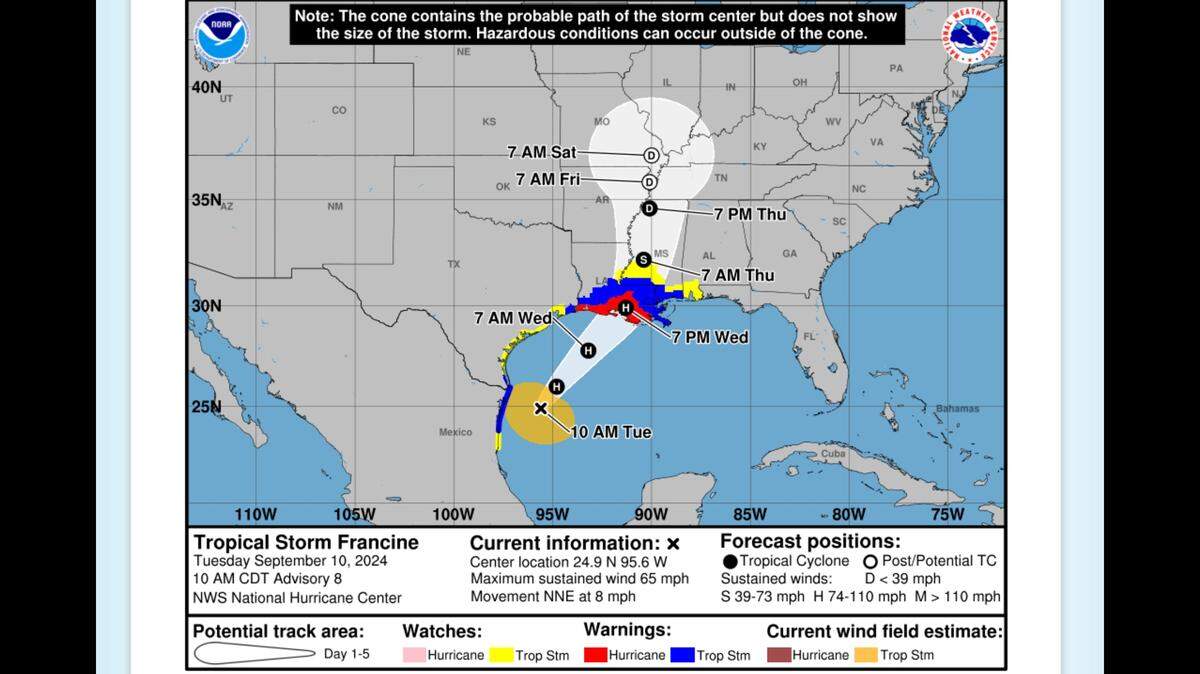
Francine is 360 miles southwest of Morgan City, Louisiana and is moving northeast at 10 miles per hour, forecasters said. “Strengthening is expected through Wednesday morning, and Francine will likely become a hurricane tonight,” the National Hurricane Center said in a 4 p.m. advisory.
Tropical storm conditions are expected to begin early Wednesday.

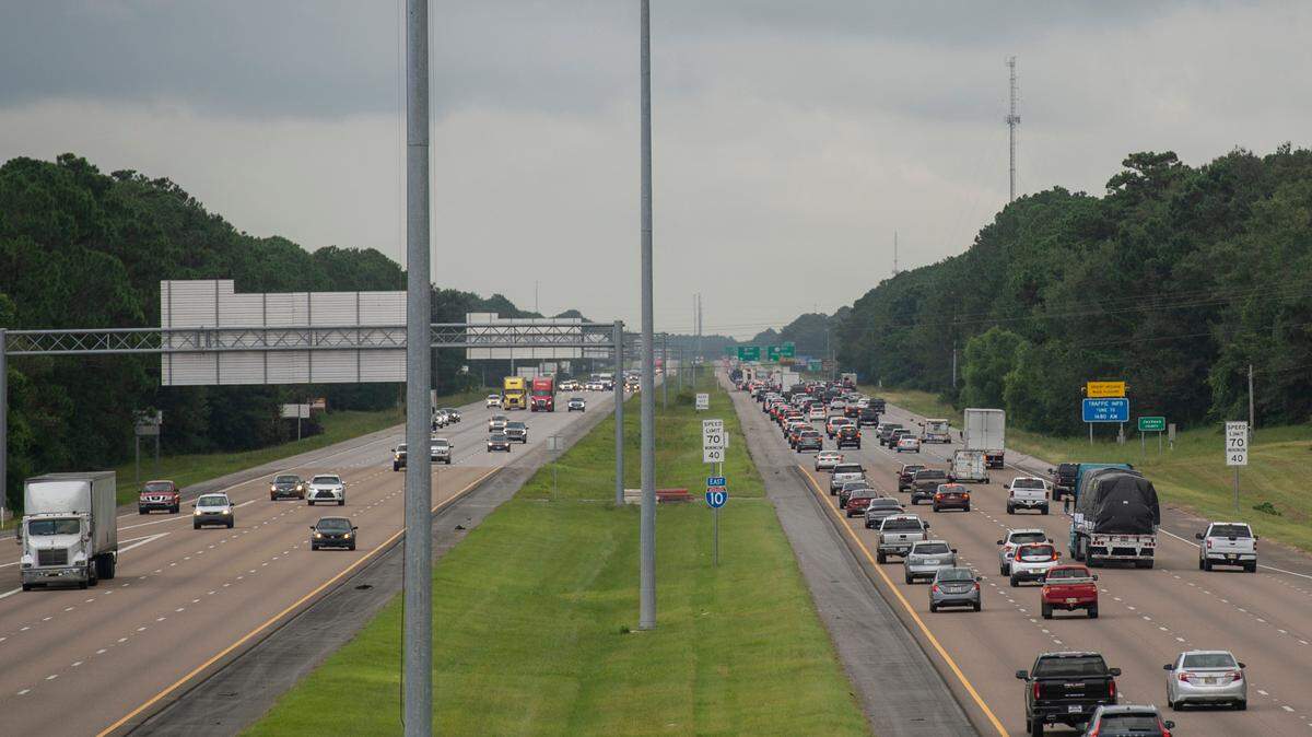
3:55 p.m.: Problem on I-10
Drivers fleeing Tropical Storm Francine on Interstate 10 are encountering trouble at the Mississippi-Alabama line. A camper overturned in the median is slowing drivers near Franklin Creek Road, Mississippi Highway Patrol Trooper Landon Orozco said. Another vehicle also crashed in the median on I-10 near Exit 61 to Gautier, Orozco said. No injuries were reported.
3 p.m.: Deadline nears for moving boats
Mississippi Department of Transportation advises that any boats that need to shelter on the back bay or need move inland via one of the drawbridges have a deadline of 6 p.m. Tuesday.
Tropical storm force winds prompted MDOT to remove the gate arms on drawbridges on MS 605, MS 609, and I-110. The gate arms will be removed just before 6 p.m. and the bridges will be locked down and closed to marine traffic until after the storm passes.
Popp’s Ferry and Cedar Lake bridges will operate as normal until noon Wednesday, when they close to marine traffic.
Pass Christian also orders a mandatory evacuation for the harbor.
2 p.m.: Casino plans partial closing
The Mississippi Gaming Commission is monitoring the weather as Tropical Storm Francine approaches.
“We’re definitely watching,” said Jay McDaniel, executive director of the Mississippi Gaming Commission. He’s already communicated to the casino operators that the Gaming Commission will allow them to decide whether to stay open depending on conditions, unless an evacuation order comes from the local emergency management officials
The most likely of the 12 Coast casinos to have flood and storm surge issues is Silver Slipper Casino in Hancock County.
General Manager John Ferrucci said they are encouraging guests at the Silver Slipper hotel and the RV park to leave by tonight, before the water rises.
“We expect our road will be covered in the morning,” he said.
The buffet and table games will not open Wednesday, he said. The slot department will be open along with the Palm Court Cafe 24-hour restaurant.
“We have storm crews,” he said, who work shifts and get free lodging and meals. “The only people who are here are those who volunteer to do that.” Ferrucci said. The casino is like a shelter for some. “They feel safer here than in their own house,” he said.
Hollywood Casino posted on social media the Bridges Golf Club will be closed on Wednesday.

1:55 p.m.: Nearly all schools closed
St. Alphonsus Catholic is the latest school to cancel Wednesday’s classes. Nearly all MS Coast districts and schools have announced their plans for tomorrow.

1:50 p.m.: Latest MS Coast risks
The Mississippi Coast should expect downed trees, strong winds and possible tornadoes near the Louisiana border on Wednesday as Tropical Storm Francine moves toward the Louisiana coast, the National Weather Service in New Orleans said.
Forecasters also warned another eastward track shift is possible before landfall.
In a 1:30 p.m. live briefing, the agency warned residents to expect strong winds along the Pearl River that will damage trees, mobile homes, and roofs, and also lead to power outages.
The winds will likely arrive Wednesday morning and spread inland through the day, forecasters said.
Tornadoes are expected in the outer bands of Francine, which could impact the Louisiana-Mississippi border.
Forecasters also warned recent heavy rains have saturated the region, which can make trees fall more easily and also lead to more flooding because new rainfall has fewer places to go.

1:05 p.m.: The new-look cone
The National Hurricane Center’s much-publicized new cone of uncertainty is in use for Tropical Storm Francine, looking much like the old cone of uncertainty but with a major twist.
1 p.m.: Latest Hurricane Center update
Tropical Storm Francine churns slowly through the western Gulf of Mexico on Tuesday afternoon and is forecast to become a hurricane by Tuesday night, the National Hurricane Center said.
The storm’s track did not shift in the National Hurricane Center’s 1 p.m. update. Francine is 380 miles southwest of Morgan City, Louisiana and moving northeast at 9 miles per hour, forecasters said.
The storm is expected to strengthen and speed up Tuesday night. Its maximum sustained winds were 65 miles per hour Tuesday, and tropical storm-force winds reach 140 miles from its center.
Tropical storm and storm surge warnings are still in effect for the Mississippi Coast. Forecasters said waters could rise 3 to 5 feet on the Coast, and the strongest winds are expected in Hancock County.
12:50 p.m.: Parks and offices closing
Jackson County closed its park and recreational facilities today. County offices and the landfill will close at noon Wednesday.
Waste Management trucks will run the regular schedules Wednesday and Thursday. Residents should secure their garbage and recycling containers.
12:20 p.m.: More school closures
Pascagoula-Gautier and Ocean Springs school districts are the latest to cancel Wednesday classes.
Noon: Francine disrupts more schools and Shuckers’ game
The list of schools closing Wednesday and possibly Thursday continues to grow across South Mississippi. Here’s the latest list.
Francine also is closing Mississippi Aquarium in Gulfport Wednesday and canceling the Biloxi Shuckers game in the last homestead of the season.
The games against the Mississippi Braves are postponed on Tuesday and Wednesday. Tuesday’s game will be made up as part of a doubleheader on Thursday, starting at 5:35 p.m. Wednesday’s game will be made up at a later date. Gates will open at 5 p.m. Thursday and both games will be seven innings.
The weather is expected to be sunny in Biloxi at 4 p.m. Saturday, when the stadium officially is renamed Keesler Federal Park.
11:30 a.m.: Boat evacuation is a slow go
Bay St. Louis issued a mandatory evacuation order for the marina at the foot of downtown. Evacuation should begin immediately and be completed by day’s end, city officials say.
The city has 184 slips in use. Bay Harbor Master Sean Hales is at the harbor and says not a lot of boats are evacuated.

”I’m not looking for a whole lot of movement because it’s kind of a little bit of short notice,”” he said.
The mandatory evacuation of the marina was ordered Tuesday morning, and by 11:30 a.m., about 20 vessels had been removed. Hales is helping remove power pedestals on the docks at the marina.“We don’t want them to go under water with all the electric components in them.”The power pedestals are used to connect boats to power in the harbor.

11 a.m.: Cell phones blare more storm warnings
Cell phones and emergency radios blared tropical storm and storm warnings warnings for the three Coast counties. Flood warnings also are in effect:
Surge Warnings means a danger of life-threatening inundation, from rising water moving inland from the coastline in the next 36 hours. The risk continues through Friday morning.
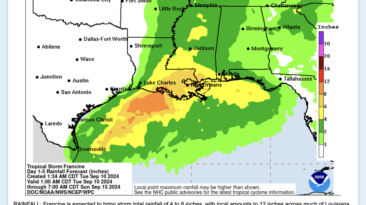
▪ Hancock County: Peak winds forecast of 25-35 mph with gusts to 50 mph. Flood Watch is in effect with rainfall amounts of 4-8 inches possible, with locally higher amounts.
▪ Harrison County: The potential for 3-5 feet storm surge above ground. Peak wind forecast of 10-20 mph with gusts to 40 mph. Flood Watch is in effect. Rainfall amounts of 4-8 inches, with possibly higher local amounts.
▪ Jackson County:wind forecast of 10-20 mph with gusts to 40 mph. Potential for major flooding rain. Flood Watch is in effect. Rainfall amounts of 3-6 inches with locally higher amounts.

10 a.m.: Schools closing
Bay-Waveland and Hancock County were among the first school districts in South Mississippi to announce closings ahead of Francine. Pass Christian and other school districts in Harrison County are expected to decide whether to close schools after meeting with the Harrison County Emergency Management Agency Tuesday afternoon.
8:30 a.m. update
As South Mississippi residents head out to fill their gas tanks and stock up on batteries, eggs and Pop Tarts, extra supplies are being shelved. “We’ve stocked up with extra truckloads of water, ice and other supplies,” Rouses Market posted Tuesday morning.
Mississippi Emergency Management Agency says, “No matter the category of the storm, damaging winds, and flooding will occur.” MEMA says residents on the Coast should have: A go-kit ready with food, water, supplies, and important documents stored in a waterproof container; multiple ways to monitor the forecast and a plan in place on where to evacuate if necessary.

7 a.m. update
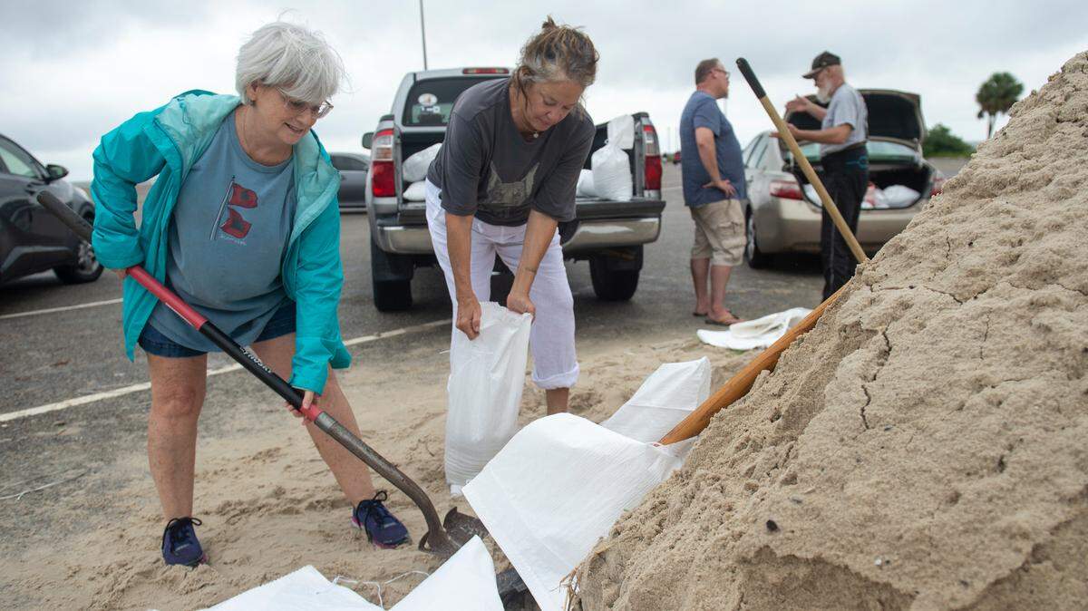
Sandbag self-serve locations are opening across the Coast as rain moves in.
Biloxi and other school districts in South Mississippi continue to watch the storm and will update parents when decisions are made whether to dismiss early or cancel classes.
Biloxi has a marina voluntary evacuation order for boats in the marinas. “Vessels should be moved to safe anchorage at the discretion of the boat owner,” the city said Monday. Other harbors also are under voluntary evacuation.
In Waveland and other cities on the Coast are reminding residents to secure garbage cans and check drainage ditches near their homes to make sure they are clear of litter and debris that might restrict water flow.
Shelters open
Hancock County
- Kiln Safe Room, opens at 10 a.m. Wednesday, 18320 Highway 43, Kiln, MS.
Harrison County
- County Farm Road Shelter opens at 10 a.m. Wednesday, 10399 County Farm Road, Gulfport.
- Lyman Community Center opens at 9 a.m., Wednesday, 14592 County Farm Road, Gulfport, will accommodate pets.
- Lobouy Road Shelter opens at 9 a.m. Wednesday, 9505 Lobouy Road, Pass Christian.
- Safe Room opens at 10 a.m. Wednesday, 15625 Lamey Bridge Road, Biloxi.
Jackson County
- Central Jackson County Shelter opens at 9 a.m. Wednesday, 5500 Ballpark Road, Vancleave, MS
- County Safe Room, opens at 10 a.m. Wednesday, 5500 Ballpark Road, Vancleave.
Pearl River County
- Picayune Community Safe Room opens at 8:00 p.m. Tuesday, 501 Laurel St. Pets are not allowed. Please bring food, water or any other needed items.
- Poplarville Community Safe Room opens at 8:00 p.m. Tuesday, 124 Rodeo St.
Pike County
- McComb Safe Room opens at 10 a.m. Wednesday, 2017 Quinlivan Road, McComb.
City and county closings and garbage
Hancock County — Coastal Environmental Services schedule has changed. Only the Diamondhead route will run as scheduled Wednesday and carts should be at the curb no later than 4 a.m. All other customers normally serviced Wednesday will be serviced on Saturday. Regular runs are planned for Thursday and Friday.
Jackson County — Parks, ball fields, boat launches and arenas in Jackson County are closed.
▪ Jackson County offices and the Jackson County Landfill will close Wednesday at noon.
▪ Waste Management trucks will run the regular schedules in Jackson County Wednesday and Thursday. Residents should secure their garbage and recycling containers.
Gautier — City offices will be closed Wednesday. Waste Pro will collect garbage Wednesday morning. Residents are asked to bring in their containers immediately after pickup.
Long Beach Municipal Court is canceled on Wednesday, For more information call 228-865-7840. City offices will be closed along with the senior center. The Jeff Davis Avenue entrance to the harbor closes at midnight Wednesday. The Cleveland Avenue entrance remains open for sandbags and access to restaurants.
Ocean Springs city offices and parks will be closed Wednesday.
Pascagoula — City offices and parks will be closed Wednesday. Waste Pro will run the normal route Wednesday but will start earlier.
Waveland City Hall is closed Wednesday.
Restaurant and business closings
▪ Coterie restaurant in Long Beach will be closed Wednesday.
▪ Ingalls Shipbuilding in Pascagoula has altered its work shifts for Wednesday. The first shift will operate as usual. Second shift will end at 7 p.m. Third and fourth shifts are canceled. Operations are scheduled to resume at 6 a.m. Thursday.
▪ Pav & Broome Fine Jewelry in Gulfport will be closed Wednesday.
▪ Silver Slipper Casino will close the buffet and table games Wednesday, along with Blue Bayou restaurant, the gift shop and valet.
▪ Southeast Commercial Real Estate office in Gulfport will be closed Wednesday.
Closings and cancellations
▪ Keesler Air Force Base will close Wednesday until further notice to all nonessential personnel. The Youth Center and Child Development Centers also will be closed. The Commissary and Base Exchange will not stay open after hours, today Sept. 10, 2024.
▪ County Health Departments are closing Wednesday. Pearl River and Hancock counties will be closed all day. Harrison and Jackson counties are closing at noon. Stone County closing at 2:00 p.m.
▪ Keesler Air Force Base announces a closure for all non-essential personnel on Wednesday. Keesler’s Division Street gate will close at 6 a.m. until further notice. The Youth Center, Child Development Centers and the Commissary and Base Exchange will be closed Wednesday.
▪ Naval Construction Battalion Center in Gulfport will reduce manning Wednesday and several base services will be closed. The Navy Exchange Commissary, Child Development Center, Youth and Tenn Centers and all Morale, Welfare and Recreation facilities also will be closed. Colmer Dining Facility will be open for breakfast only. The NEX mini-mart will be open until 11 a.m. The gates at 28th Street and Broad Avenue and the Visitor Control Center close at noon. The The Pass Road Gate will remain open.
▪ Mississippi Aquarium in Gulfport will be closed Wednesday. Plans are to reopen at 10 a.m. Thursday.
▪ All Jackson-George Regional Library branches will close Wednesday. All library programming scheduled for Wednesday also is canceled.
▪ Southern Rail Commission changed the date of its virtual quarterly meeting that was scheduled Friday to Friday, Sept. 20 at 9 a.m.
▪ Gulf Islands National Seashore will close the entire Mississippi District at 4 p.m. Davis Bayou Campground closed at noon.
▪ Gulf Islands National Seashore on Monday closed the National Park Service-managed areas of the barrier islands in Mississippi. Ship Island Excursions to Ship Island is closed.
The U.S. Department of Agriculture Forest Service temporarily closed these recreation areas in South Mississippi:
▪ De Soto Ranger District, all recreation areas, including the Big Biloxi Recreation Area and Campground, Cypress Creek Campground, POW Lake, and Black Creek Wilderness
▪ Chickasawhay Ranger District, Turkey Fork Recreation Area, Chickasaw ATV/motorcycle trail, and Longleaf horse trail
▪ Homochitto Ranger District, Clear Springs Recreation Area close at 4 p.m. Tuesday.
Sandbag sites
Harrison County — sites open at 7 a.m. Tuesday. Bags and sand will be provided. Residents must bring their own shovels and fill the bags themselves.
▪ Harrison County Road Department, 10076 Lorraine Road, Gulfport
▪ D’Iberville Work Center, 10085 First Ave., D’Iberville
▪ Woolmarket Work Center, 16395 Woolmarket Road, Biloxi
▪ Lyman Work Center, 15001 County Farm Road, Gulfport
▪ Orange Grove Work Center, 8300 34th Ave., Gulfport
▪ Courthouse Road Pier, 96 Courthouse Road, Gulfport
▪ Long Beach Harbor, 720 S. Cleveland Ave., Long Beach
Biloxi — self-serve sandbags are available Tuesday and Wednesday at:
▪ Henry Beck Park, 671 Division St.;
▪ Migues Park, 425 Parker St..
▪ A.J. Holloway Sports Complex, 765 Wells Drive,
▪ Fire Station 8 at 8479 Woolmarket Road; and
▪ Fire Station 9, 9370 Oaklawn Road.
Gulfport — Self serve sand and bags are available at one location.
▪ Corner of Hewes Avenue and Glover Street.
Hancock County — Self serve sand and sand bags begins at 8 a.m. Tuesday. Bring your own shovel. Those who need help getting the sand bags should call Hancock County Emergency Management Agency at 228-255-0942 or Hancock County Central Dispatch at 228-255-9191.
▪ Emergency Operations Center/Storm Prep Building, 18333 MS 603
▪ Old Hancock County Complex, 3068 Longfellow Drive
▪ Lakeshore Community Center, 6440 Lower Bay Road
▪ Bayside Fire Department, 6215 West Hinds St.
▪ West Hancock Fire Department, 16006 Washington St.
▪ Diamondhead City Hall, 5000 Diamondhead Circle
Jackson County — Self-serve locations open at 7 a.m. Tuesday
▪ Ocean Springs — Public Works Department, 712 A Pine Drive
▪ Ocean Springs — West Division Roads Department, North Washington Ave. (MS 609)
▪ Ocean Springs — Fountainbleau Fire Department, 3901 MS 57 South
▪ Ocean Springs — St. Andrews Fire Dept., 1401 Elm St.
▪ Gautier — Behind City Hall on U.S. 90
▪ Moss Point — Forts Lake Fire Department, 10701 Forts Lake Road
▪ Moss Point — New Central Fire Station, 4204 Bellview St.
▪ Moss Point — East Division Roads Department, 10825 MS 63
▪ Vancleave — Central Division roads Department, 8500 Jim Ramsey Road
The Sun Herald will update this article throughout the storm. Send closings to MyNews@sunherald.com.
This story was originally published September 10, 2024 at 8:08 AM.