
Heat index over 90, more severe weather possible for Mississippi Coast this week
The heat index on Monday was expected to climb above 90 in parts of South Mississippi and southeastern Louisiana for the first time this year, and more severe weather is possible Tuesday.
“It is that time of the year when we begin to warm up,” The National Weather Service in New Orleans warned. “Combine that with the high humidity and the head indices start to climb into the mid-90s and even upper 90s.”
The highest temperatures were expected inland in Hancock and Pearl River counties as well as near Slidell.
The weather service advises those outdoors to drink plenty of water, apply sunscreen regularly, wear loose clothing, and take breaks in the shade to protect themselves from the heat.
After several inches of 2-3 inches of rain on the Coast on Sunday, Monday brought gray skies and a flash flood watch until 1 a.m. Tuesday.
Stronger storms are expected Tuesday, and the weather service said to expect a marginal to enhanced risk (levels 1-3 out of 5) of severe weather and widespread excessive rainfall, with 1 to 3 inches possible.
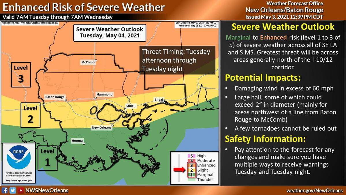
The timing of the rain is forecast for the afternoon and evening.
Meteorologist Danielle Manning told the Sun Herald a heavier rain threat could lead to flash flooding.
As with any severe storm, wind gusts over 60 mph will be possible as well as tornadoes and large hail 1 inch in diameter.
Hail of over 2 inches is possible northwest of a line from Baton Rouge to McComb, the weather service said.
There is a flood warning for parts of the Mississippi River and Pearl River through mid-week.
Forecast for MS Coast
Tuesday
A slight chance of showers, then showers and thunderstorms likely after 1 p.m. Cloudy, with a high near 83. South wind 10-15 mph. Chance of precipitation is 60%. New rainfall amounts of less than a tenth of an inch, except higher amounts possible in thunderstorms.
Tuesday Night
Showers and thunderstorms likely before 1 a.m., then showers likely and possibly a thunderstorm after 1am. Mostly cloudy, with a low around 67. South wind 5-10 mph. Chance of precipitation is 70%.
Wednesday
Showers likely and possibly a thunderstorm before 1 p.m., then a chance of showers and thunderstorms after 1 p.m. Partly sunny, with a high near 80. West wind 5-10 mph. Chance of precipitation is 60%.
Wednesday Night
A 20% chance of showers after 1am. Partly cloudy, with a low around 63. North wind around 5 mph.
Thursday
A slight chance of thunderstorms before 7 a.m. Sunny, with a high near 80. North wind around 5 mph. Chance of precipitation is 10%.
Thursday Night
Mostly clear, with a low around 59. North wind around 5 mph.
Friday
Sunny, with a high near 79. Northeast wind around 5 mph becoming south in the afternoon.
Friday Night
Mostly clear, with a low around 63. South wind around 5 mph becoming calm in the evening.
Saturday
Sunny, with a high near 79. Southeast wind 5 to 15 mph.
Saturday Night
Partly cloudy, with a low around 68. South wind around 10 mph.
Sunday
A slight chance of showers and thunderstorms. Mostly sunny, with a high near 82. South wind 10 to 15 mph.
This story was originally published May 3, 2021 at 1:50 PM.