
Fierce storms could bring strong tornadoes to South Mississippi
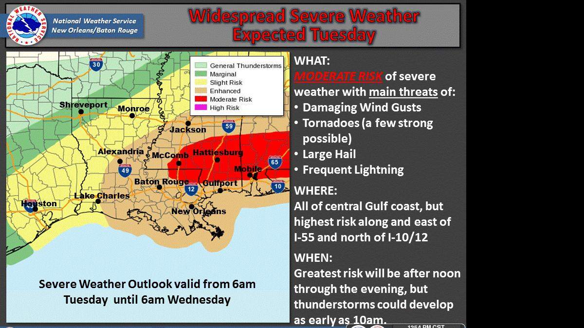
ATLANTA -- Fierce storms could bring strong tornadoes, hail and damaging winds to South Mississippi and several states in the Deep South on Tuesday, forecasters say.
The National Weather Service estimates that more than 7 million people in parts of five states -- Louisiana, Mississippi, Alabama, Florida and Georgia -- are in an area of enhanced risk for a few strong tornadoes and other severe weather during Tuesday's storms.
Meteorologists at the national Storm Prediction Center in Norman, Oklahoma, say the areas at highest risk of the most dangerous storms will be in southern Alabama and southern Mississippi, along with slivers of northeast Louisiana and northwest Florida. That area includes the cities of Mobile and Hattiesburg, as well as Pearl River, Stone and George counties.
The system will bring "a pretty substantial risk for supercells" that could spawn strong tornadoes, but also lines of storms that pose threats as well, said Greg Carbin, a meteorologist at the Storm Prediction Center.
"We definitely are starting to move into that time of year where the ingredients for these types of storms are beginning to come together," Carbin said.
On the Mississippi Coast, storms with large hail, damaging winds and isolated tornadoes are expected to arrive between 6 p.m. and midnight, and exit the area by 1 a.m. Wednesday.
The weather service in Slidell has issued a wind advisory for 10 a.m. Tuesday until 6 a.m. Wednesday, with gusts up to 40 mph. A small craft advisory is also in effect from 9 a.m. to noon Tuesday and gale warning from noon to 9 a.m. Wednesday.
Temperatures are expected to start dropping Wednesday, with lows in the upper 30s by Friday.
In Louisiana, storms could hit the New Orleans area from midafternoon Tuesday through early evening, said Andrew Ansorge, a weather service meteorologist in Louisiana.
The storms are forecast to spread east across Alabama and into Georgia and north Florida, posing a threat into the evening, Carbin said.
In Alabama, a large part of the state will be under an elevated risk of storms late Tuesday afternoon through early Wednesday morning, according to forecasts from the weather service. That area -- which includes Birmingham, Montgomery, Mobile, Auburn and Tuscaloosa -- could see tornadoes, winds of up to 70 mph, and quarter-sized hail, the weather service projects.
In Georgia, a total of 3.4 inches of rain is expected in Atlanta from showers and storms Monday through Wednesday, which could produce some flooding, according to forecasts from the weather service's office in Peachtree City, Georgia.
Lauren Walck, Sun Herald assistant editor, contributed to this report.
This story was originally published February 22, 2016 at 4:37 PM with the headline "Fierce storms could bring strong tornadoes to South Mississippi ."